Time is Running Out: Floridians Brace for Future Hurricane Helene
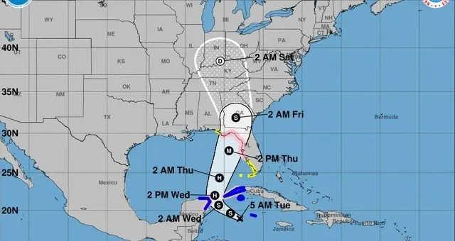
Florida is on high alert as time quickly runs out to prepare for the potentially devastating impacts of Hurricane Helene, which is set to become the most powerful storm to hit the United States in over a year. Although the storm has not yet formed, meteorologists predict rapid intensification over the warm waters of the Gulf of Mexico, turning Helene into a Category 3 major hurricane within just 48 hours.
With the storm’s fast development and dangerous potential, Floridians must act now to prepare for life-threatening storm surge, damaging winds, and flooding rainfall. Here’s what you need to know as Hurricane Helene approaches.
Rapid Intensification: What to Expect
As Hurricane Helene forms and gathers strength, it’s expected to intensify swiftly, creating an incredibly short timeline for preparation. The storm will likely evolve from a tropical storm into a major hurricane within two days, driven by extremely warm Gulf waters. This rapid intensification poses a serious threat, with forecasts warning of:
- Torrential rain
- Hurricane-force winds capable of widespread damage
- Tornado threats across the region
The storm will be large and powerful, impacting areas far beyond Florida, with strong winds and heavy rain stretching across much of the Southeast. States like Georgia, Alabama, and the Carolinas should also brace for significant weather effects.
Coastal Evacuations and Surge Risks
Evacuations are expected to begin as early as Tuesday for coastal Florida residents facing the highest risk of storm surge. In Florida’s Big Bend region, an evacuation order is anticipated, as the area could experience storm surges up to 15 feet, which could be catastrophic for coastal communities. The Tampa Bay area also faces surge risks, with up to 8 feet of water possibly inundating parts of the city and surrounding areas.
Tampa General Hospital, anticipating the storm’s impact, has already erected a 10-foot-high flood barrier as a precaution against the rising waters.
State-Wide Preparations: Emergency Declarations and Support
In response to the looming threat, Governor Ron DeSantis has expanded an emergency declaration from 41 counties to 61 out of Florida’s 67 counties. This move expedites coordination between local and state authorities, ensuring swift preparations for the storm’s arrival.
- 3,000 members of the Florida National Guard have been activated to assist with storm efforts.
- The Florida State Guard is also ready to provide emergency response, with hundreds of Starlink units

